YARD TOPOGRAPHY & GRADING
Understand the ground around your home.
MultiView Inspections combines measured ground elevations with clear diagrams to help explain the slopes and grading around your home.
The Grading and Drainage Report connects those measurements to the areas evaluated, giving you a visual reference for understanding the yard and discussing potential drainage concerns.

The yard is part of the home’s water-management system.
The shape of the ground influences where surface water travels and where it can collect. Ground that slopes toward a home can direct runoff toward the foundation, while appropriate grading and drainage features help carry water away.
Understanding those conditions is an important part of evaluating the property, not just its landscaping.

Understand drainage near the foundation
Measured slopes add detail to the evaluation of ground conditions around the home. They can help identify areas that deserve closer attention because the ground falls toward the structure or lacks a clear surface-drainage path.

Put low areas and runoff in context
Depressions can collect water, and soil conditions affect how quickly that water soaks into the ground. Measurements help identify the shape of an area, while visible conditions provide additional information about what may be happening there.

Ask better questions before making changes
Before adding a patio, changing landscape beds, or addressing a drainage concern, it helps to understand the existing slopes and surfaces. The report provides background for that discussion; a qualified professional must determine any needed design or corrective work.
Look beyond whether the lawn appears level.
A yard does not need to be perfectly flat to function well. Slopes, low areas, surface materials, and drainage features work together to influence where runoff goes. Paved surfaces also reduce the amount of water that can soak into the ground and can concentrate surface runoff.

Ground sloping toward the home
A slope toward the structure may direct surface runoff toward the foundation.

A low area that may collect water
A depression can hold water depending on rainfall, soil absorption, and available drainage.

Connected drainage conditions
Roof runoff, paving, landscape beds, and visible obstructions can affect the route water takes.
Conceptual examples.
THE GRADING AND DRAINAGE REPORT
Your yard, measured and explained.
MultiView Inspections organizes the recorded measurements into a property-specific Grading and Drainage Report.
The report identifies the measurement reference, shows the areas and paths measured, and explains relative elevations, slope, and grade. The inspector considers the measurement pattern alongside visible site conditions so the diagram can be understood in context.
Sample Report • Select image for full-size view
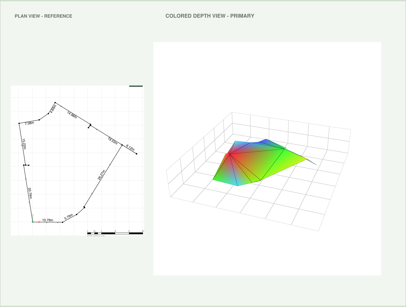
Measured area, not a legal property boundary. Original metric units are retained. Colors show relative elevation differences, not a drainage pass-or-fail result. Surfaces between recorded points are interpolated from the measurements.
1. Measured-area layout — Where measurements were collected and how those areas relate to the site.
2. Reference point — The starting point used to compare relative elevations.
3. Relative elevation information — Which recorded locations are higher or lower than the selected reference.
4. Slope and grade information — The direction and rate of elevation change between particular measured points.
Inspector-reviewed context — How the measurement pattern relates to visible grading and drainage conditions.
Scope and limitations — What the documentation represents and what it does not establish.
HOW THE MEASUREMENTS WORK
Measuring the space and its elevations together.
Motion-based measurement technology records position and elevation as selected areas are measured. Those readings create a three-dimensional record of the measured layout, capturing height differences as well as horizontal relationships.
The information can then be presented through plan views, elevation views, and other diagrams that help explain the site. The measurements are relative to a selected starting point, not automatically elevations above sea level.
1
Establish the reference
Set a starting reference so the measurements can be compared on a common basis.
2
Measure the agreed areas
Collect readings along the selected accessible paths and locations.
3
Review the site conditions
Consider the measurement pattern alongside visible slopes, drainage paths, low areas, and other relevant observations.
4
Build the report
Organize the measured layout, elevation information, and relevant explanations into the Grading and Drainage Report.

Recorded points
Measured layout
Report presentation
Conceptual measurement sequence. Surfaces between recorded points are interpolated from the measurements; they are not independently measured at every location.
Better information for the questions that follow.
A diagram is most useful when it helps you ask specific questions. Where is the ground falling toward the house? Is a low area connected to visible ponding? Could a proposed landscape change interrupt an existing drainage route?
The report provides a measured reference for those conversations. It does not prescribe a repair simply because an elevation difference appears. MVI’s reporting approach requires measurements to be considered with observed conditions and recommendations to remain proportionate to the findings.
Before buying
Use the documented observations to ask about previous drainage concerns, repairs, or changes to the yard. Where a concern is identified, discuss whether further evaluation is appropriate before proceeding.
When maintaining the property
Keep the report with the home’s records and use the documented locations when discussing visible changes or recurring concerns.
Before a landscape or drainage project
Share the report as background information with the appropriate professional. Additional measurements, soil information, design work, or approvals may still be needed. MVI’s documentation does not establish drainage-system capacity or engineering-design compliance.
What the diagram can tell you.
No. Measured slopes help explain potential surface-drainage directions, but actual water movement also depends on rainfall intensity, soil saturation, surface materials, obstructions, and drainage features. The report is not a stormwater model or a simulation of a particular rainfall event.
No. Its location, purpose, surrounding grades, and observed performance matter. Some landscape features intentionally collect or slow runoff. The inspector considers the measurements alongside the visible conditions rather than treating every low point as a deficiency.
No. A completely level yard is not the goal. Appropriate slopes and drainage features help manage runoff away from the home. The suitable arrangement depends on the site and the surfaces involved.
No. The Foundation Elevation Measurements service documents relative floor elevations inside accessible areas of the home. Yard topography and grading measurements document selected exterior ground and surface elevations. They answer different questions and should be considered alongside the relevant inspection observations.
No. It does not establish legal boundaries, certified elevations, drainage-system capacity, or a repair design. It is supplementary observational documentation of the measured areas.
No. A low area in a yard does not, by itself, determine the property’s flood-zone designation or insurance requirements. Those questions involve official flood information and applicable lending requirements, not this relative-elevation diagram.
About this documentation
Yard topography and grading measurements document selected accessible locations and conditions at the time of measurement. The Grading and Drainage Report is supplementary documentation and does not replace the home inspection, a boundary survey, an elevation certificate, a soil investigation, or a civil engineering evaluation.
The measurements do not certify drainage performance, predict flooding, or provide construction-ready grading or repair plans.
A home inspection already includes evaluation of accessible grading and drainage conditions under the applicable TREC standards. The measured diagram adds documentation to those observations.
