FOUNDATION ELEVATION MEASUREMENTS
Floor elevations,
mapped to your home.
MultiView Inspections combines a curated 2D floor plan with high-precision floor-elevation measurements. Each recorded point connects a measurement to a location, creating a clear picture of how accessible areas of the home compare.
Understand the differences, see where they occur, and keep the documentation for future reference.
On this page

Illustrative example. Selected measurement locations.
WHY THESE MEASUREMENTS MATTER
More information for an important part of the home.
A foundation concern deserves more than an isolated photograph or a number without context. Elevation documentation adds measurements to the inspection and shows how those measurements relate to the home’s layout.

Understand the differences across the home
Elevation readings quantify how selected floor locations compare to a reference point. Mapping those readings helps show whether differences are concentrated in one area or extend across several measured locations.

Give visible concerns more context
Cracks, gaps, and uneven surfaces can have different causes. A visible symptom alone does not establish foundation movement. Elevation documentation adds another source of information to consider alongside the inspector’s observations.

Establish a starting point for future comparisons
A dated set of readings provides a baseline. When future measurements use comparable locations, reference methods, and surface conditions, they can help evaluate changes in relative elevation over time.

Support a more informed next step
When further evaluation is warranted, documented readings can support a discussion with a qualified engineer or foundation professional. They provide information for that evaluation without replacing the investigation or judgment needed to determine the cause or appropriate repairs.
HOW THE INFORMATION COMES TOGETHER
A floor plan gives every reading a location.
An elevation reading is easier to understand when you can see where it was taken. MultiView Inspections brings the home’s 2D layout and recorded measurements together in one visual document.
The floor plan identifies the locations. The elevation instrument measures the vertical differences.
Step 1: Create the layout
Prepare a 2D floor plan that provides a visual reference for the home and the locations being documented.
Step 2: Set the reference
Establish a zero reference so the readings can be compared on a common basis.
Step 3: Record the elevations
Take relative elevation readings at selected, accessible floor locations.
Step 4: Connect the information
Place the recorded readings on the layout so their locations and relationships are clear.
2D floor plan

Measurement locations

Completed elevation diagram

Illustrative example. Readings shown are for demonstration only.
The instrument’s zero function establishes a comparison reference. It does not mean that location is at sea level, is the home’s original construction elevation, or is guaranteed not to move.
HOW THE MEASUREMENTS WORK
The technology behind the readings.
MultiView Inspections uses digital hydrostatic technology to measure relative height differences between selected floor locations. These readings add measured detail to the inspector’s observations and connect that information to the home’s layout.
A defined reference
Measurements are compared with an established reference point so the recorded differences have a consistent starting point.
Careful measurement methods
Proper setup and consistent technique support useful documentation at selected, accessible locations throughout the home.
Conditions documented alongside the readings
Floor coverings, intentional changes in floor height, and access limitations provide context for understanding the measurements.
Measurements you can see in context.
The completed diagram connects the recorded elevation readings to the home’s layout. Instead of reviewing a disconnected list of numbers, you can see the measured locations and how they relate to one another.
It becomes a practical reference for reviewing the inspection findings, asking follow-up questions, and retaining the information with the home’s records.
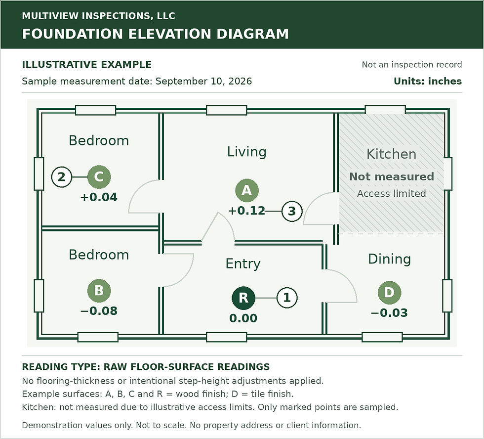
1 | Reference point
The location used as the zero reference for the measurements.
2 | Recorded locations
The points where readings were actually taken.
3 | Relative elevation readings
How each measured location compares with the reference.
- Illustrative example
- Sample measurement date: September 10, 2026. Units: inches.
- Raw floor-surface readings. No flooring-thickness or intentional step-height adjustments applied.
- Example surfaces: A, B, C and R = wood finish; D = tile finish.
- Kitchen not measured due to illustrative access limits. Only marked points are sampled.
Reading the numbers
A positive reading indicates a measured location above the selected reference. A negative reading indicates a location below it. These values describe relative height, not automatically the amount a foundation has settled or risen.
What the readings can tell you.
Not necessarily. A single set of measurements documents the floor elevations at that time. Construction variations, floor coverings, and intentional changes in floor height can affect the readings. The numbers must be considered alongside the property’s conditions and available history.
Yes, when they are compared appropriately. Documented measurement locations and a consistent reference method make later comparisons more useful. Changes to flooring, reference points, or measurement methods must be accounted for before treating a difference between reports as movement.
Yes. An initial measurement record provides a starting point for future comparison. Its value is not limited to homes where someone has already noticed a crack or an uneven floor.
No. The measurements can support further evaluation, but they do not establish a repair design. Decisions about the cause of a condition and the appropriate repair require consideration of the structure, observed conditions, and other relevant information.
ⓘ
About this documentation
Foundation elevation measurements supplement the inspection. Readings are taken at selected accessible locations and represent conditions at the time of measurement. The 2D layout supports the presentation of those readings; it is not an architectural plan or boundary survey. This service does not replace a structural engineering evaluation or repair design.
Start with a documented reference.
Bring measured detail to your understanding of the home. Contact MultiView Inspections to discuss foundation elevation documentation and the inspection services that fit your property.
Included with CORE and 360
Serving the Permian Basin.